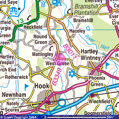
Where are we?
The Parish of Mattingley is an area of about 10 square miles in the north east of Hampshire. There are two roads through the Parish: the B3349 and B3011. It is surrounded by the Parishes of Hartley Wintney to the south, Bramshill to the east, Heckfield to the north and Rotherwick to the west. It is about 8 miles to the east of Basingstoke and about 9 miles south of Reading.
From the M3 (junction 4A):
Follow signs to Hartley Wintney and at the second mini roundabout turn right on to the B3011.
From the M3 (junction 5):
Follow the signs to Hook and then Reading. The B3349 passes right through the centre of Mattingley.
From the M3 (junction 6):
Follow the signs to Basingstoke and then take the A33 to Reading. Turn right opposite the Wellington Monument and follow the signs to Heckfield and then Mattingley.
From the M4 (junction 11):
Take the A33 towards Basingstoke. At the end of the dual carriageway, turn left onto the B3349 and follow the signs to Heckfield and then Mattingley.
 Get-a-map service. Image reproduced with kind permission of Ordnance Survey and Ordnance Survey of Northern Ireland.
Copyright © 2006-2017 Mattingley Parish Council. All rights reserved.