History of Hartlip

HARTLIP is a name given to two different entities as records clearly show:
1. Hartlip is the name given to the ancient village of Hartlip which centres on The Street and encompasses Hartlip Conservation Area.
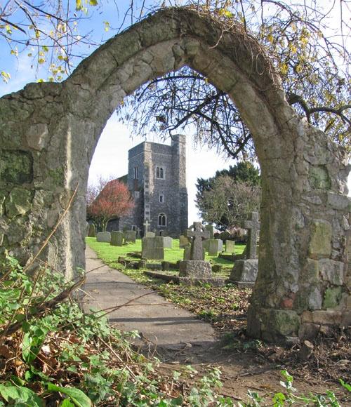
This is where the Grade 1 Listed Church of St Michael and All Angels which dates back to the 13th Century and the Grade 2 Listed War Memorial are located. Many of Hartlip’s Grade 2 Listed buildings can be found in the ancient village.
There are special Heritage Assets in the ancient village such as one of the earliest Methodist Chapels in Kent, Cardiphonia, built in 1820 and Hartlip Endowed Voluntary Aided Church of England Primary School founded in 1678 and which is one of the oldest endowed primary schools in the country.
Also on The Street is the Village Hall. A meeting place in a barn belonging to Yew Tree Farm can be traced back to the 1800’s. The present Village Hall was built in 1932 and incorporated this barn. The hall benefits from a private car park for the use only of those hiring and attending the Village Hall. The Village Hall was registered as a charity in May 1969 and this was a very significant change. That decision meant that from then on, the facility must be managed according to its Trust Deed, Charity Law and any other relevant laws. The charity is managed by a Management Committee who must, amongst other things:
‘must make sure that the charity is carrying out the purposes for which it is set up, and no other purpose’.
‘make sure the charity’s assets are only used to support or carry out its purposes’.
Situated in this area is a very well used Allotment Area which has served this purpose since the 1800’s and is managed by Hartlip Parish Council.
Opposite the Methodist Chapel is the Village Pond which, in times past, was The Old Wheelwash. The front section of the pond and the triangle of land adjacent to it and to the south is Parish land. On the triangle of land was placed Hartlip’s Platinum Jubilee Bench in 2022 to mark the 70-year reign of Queen Elizabeth the Second. Prior to the wall which separates the pond from the road today, stood a fence and prior to that nothing at all. Photographs from days gone by evidence this. Today this Heritage Asset is the Village Pond and assists with road drainage.
The Street is also home to Old Parsonage and the Old Vicarage and is a heavily populated area with buildings along the whole of both sides.
2. Hartlip is also the name given to the Civil Parish of Hartlip which includes and spreads beyond the ancient village. It includes:
(a) The ancient village of Hartlip.
(b) Hartlip Hill at the north of the civil Parish.
Mill Lane passes from the A2 (Watling Street), up Hartlip Hill and eventually meets The Street i.e. the start of the ancient village.
In times past Mill Lane was known as ‘Hartlip Road’ or ‘the road to Hartlip’ and The Street was sometimes called ‘Stockbury Road’ or ‘the road to Stockbury’.
Hartlip Mill was on Hartlip Road/Mill Lane until it burnt down in 1880.
Interestingly, at the northern end of Hartlip Hill can be found the remains of an old ‘lock-up’.
(c) Lower Hartlip to the east of the ancient village of Hartlip and reached from the A2 (Watling Street) via Lower Hartlip Road (‘the road to Lower Hartlip’).
Lower Hartlip includes Lower Hartlip Road (which is home to the Rose and Crown Public House), Munns Lane, Grainey Field, Auger Close and Old House Lane.
(d) Queendown Warren to the south of the ancient village.
(e) Rural lanes to the west of The Street.
So, ‘Hartlip’ is the name given to both an ancient village and a civil parish in the Borough of Swale in the County of Kent.
The name Hartlip derives from the Old English ‘hliep’ meaning a gate or fence and ‘heoret’ meaning hart or stag.
‘Hartlip’ therefore means ‘gate over which harts leap’.
Hartlip Civil Parish is situated in the Garden of England where traditionally fruit, hops and grain have been grown.
It extends over 1422.547 acres and had a recorded population of 746 in the 2011 Census.
Hartlip civil parish has a rich heritage which is important to residents who value highly the Conservation Area.
The Parish grew around the manors which existed in medieval times to provide accommodation for farm labourers and servants. These were the Manor of Yaugher, the Manor of Hartlip and the Manor of Greyney.
In the southwest of the Parish the remains of a Roman Villa complex were found during excavations in 1750. The site of the Roman villa revealed during the 18th and 19th centuries had a bath building, hypocausts, plastered walls and a barn probably dating from 3rd to 4th century AD.
Plans were drawn and the remains reburied to preserve them.