Inclined Plane

Construction of the Wrockwardine Wood inclined plane began about 17th January 1791 after the Ironmaster, John Wilkinson had personally petitioned Parliament to extend the Shropshire Canal from Snedshill to form a junction with the Donnington Wood Canal.
The slope of the incline measured about seven degrees. The plane spanned the descent of 113 feet 2 inches and measured nine hundred and forty eight feet in length. The engine that served the plane’s lifting operations was the work of Adam Heslop of the Ketley Works and had a 12 inch bore and a 7 foot 6 inch stroke.
Between June 1791 and December 1792 records of the nearby Snedshill Ironworks near Oakengates, record making 193 tons of cast iron rails from the works were fitted on the plane. The wooden sleepers were made by a timber merchant named Thomas Ford of Hadley and his assistant James Houghton and were supplied by funding from the treasurer of the Canal Company, Edward Bishop. The cradles which supported the lifting operation were especially designed by a Quaker named William Prideaux of Newdale, who was a blood relative of William Reynolds.
In April 1795 subsidence beneath the plane, which may have been due to subterranean tunnels running underneath the engine house, was reported and a fissure three inches wide opened up across the housing. At that time, the new brickwork in the upper bay of the inclined plane was damaged showing that the mines were actually subsiding under the machinery.
In May 1797, after the partners of the Shropshire Navigation Company had entered into a dispute with local charter master over the price of carriage on the plane, Henry Williams of Ketley, Engineer took away the ropes and special carriages, rendering the plane unusable for a period.
Four bitter years of trouble followed during which local charter master used a much more economical railway built by John Bishton in 1796, which ran parallel to the Shropshire Canal.

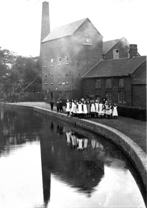
Donnington Wood Mill
Between 1818 and 1821 a partnership was formed to mill, bake, and deal in grain, and a four-storeyed brick steam mill was built in 1818 on the north bank of the Shrewsbury Canal.
The mill, generally known as Donnington Wood mill, closed in the 1970s. (ref. http://www.british-history.ac.uk)
Four bitter years of trouble followed during which local charter master used a much more economical railway built by John Bishton in 1796, which ran parallel to the Shropshire Canal.
The Old Canal (by Norman Pickering)
I was quite young, but I remember feeling quite sad when they drained the Old Canal.
I recall a sunken coal barge was revealed near the Old Yard.
The canal was at the top of the old incline near the Trench Lock and went all the way to Lilleshall Abbey without a lock.
At Teagues Bridge there was a single track iron bridge similar to three others along our stretch.
From there it went into a sort of ox-bow called the Mot and then past the Old Mill and over Church Road.
Incidentally this was referred to by everybody as Stoney Lane, and was indeed shown as such on early 20th century Ordnance Survey Maps. Then the canal went along past Holy Trinity Church and Glasshouse Row on the site of the old glassworks.
The next stretch is still actually designated as Canal Side and so on to Furnace Lane and another bridge. Here the canal skirted “Lemuel” Jones’ small holding near to the place where the Old Incline by the Methodist Chapel came down, at the back of what is now Smiths Crescent. Here there is a brick bridge still intact.
And so we go on to the Old Yard and Muxton Bridge and across the Fields to Lilleshall.
If anyone has any memories of the area from their childhood, or any old photographs, we would be very pleased to include them in our local history page.
Please email us here or contact us on 616363. (All photos will be returned)