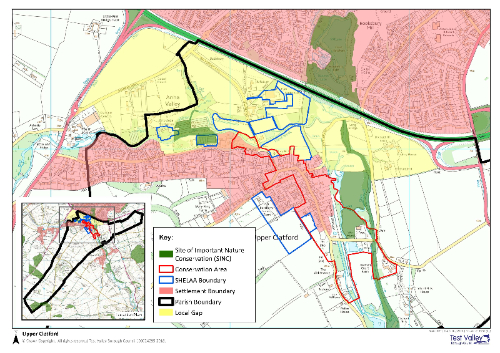
Maps and boundaries relevant to NDP
There are a number of important inputs into any NDP, relating to the existing planning boundaries and other spaces that have some status which will define of influence its future use. The map below shows all the key boundaries, most of which are linked to the area of the Anna Valley and Upper Clatford Settlement.

The above boundaries are defined in the TVBC Plan as follows:
Site of Importance for Nature Conservation (SINC)
These are local wildlife designations based on the habitats or features they contain [more information at: https://www.hants.gov.uk/landplanningandenvironment/environment/biodiversity/informationcentre/sincs ]
Conservation Area boundary
Legislation defines a conservation area as ‘An area of special architectural or historic interest, the character or appearance of which it is desirable to preserve or enhance’ [Planning (Listed Buildings and Conservation Areas) Act 1990]. The Council is responsible for the designation and review of conservation areas; this is not part of the preparation of Local Plans. The local authority has a duty to ensure that the character or appearance of a conservation area is preserved or enhanced, when considering applications for development. This includes development which affects the setting of a conservation area.
SHELAA Sites
Land promoted by the landowner / developer to be available for development through the Strategic Housing & Economic Land Availability Assessment (SHELAA). The SHELAA will only identify sites which have been promoted to the Council, it does not allocate sites. The inclusion of the site in the SHELAA does not imply that the Council would necessarily grant planning permission.
Settlement Boundary
This boundary shows the area within which the principle of development or redevelopment is acceptable, subject to other planning policy requirements, through policy COM2 in the adopted Test Valley Borough Local Plan.
The Local Gap
A planning policy designation that seeks to retain the separate identity of settlements and avoid coalescence. See policy E3 in the adopted Test Valley Borough Local Plan.
Planning Applications for this Parish
This web site has a link that will show you all the current Planning Applications for this Parish. Just click this link:
