Suggested Local Walks
This page suggests some walks in the countryside starting at Warnford Village Hall. Over time we will add more and will also start to add photographs to illustrate the walks. If you would like any further information about these walks, have any useful hints or tips for future walkers or would like some more ideas for local walks then please get in touch with Derek Chapman on 01730 829660 or email.
At the end of this page you can find all of the walks described below in printable form so you can take them with you on your adventure and hopefully not get lost.
...............................................................................................................

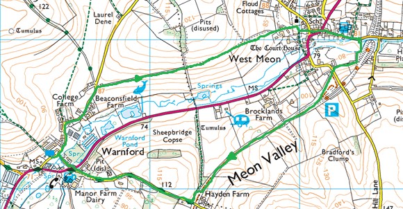
Walk 1 – West Meon & back (2¾ miles; three stiles; easy walking)
Follow Lippen Lane northward through the centre of the village and up a gentle hill through a cutting.
Just before North End Cottages, follow the steps up the bank on the right, over the stile and across the top of a big meadow, full of wild flowers in the spring. In the bottom of the valley on the right is the winding course of the Meon, leading to Moorhen Trout Farm. The big pond is fed by natural springs.
At the end of the field a stile takes you across the parish boundary – here formed of a big bank, well dug over by badgers. In Saxon times this was a “herepath” or military road, coming from Bramdean and crossing the river at Sheepbridge to ascend towards the South Downs Ridgeway.
Keep straight on along the footpath, which widens into a track. The tower of West Meon church rises up straight in front of you, with a good view of the village away to the right. If you are lucky there will be poppies along the edge of the field.
Keep on down the hill towards Floud Lane and the Courthouse Barns. Turn right at the bottom, then follow the signed path immediately on the left, which squeezes between fence and wall, then winds round and crosses West Meon churchyard wall by a stone stile.
Go diagonally across the churchyard and down the passage which brings you out at The Cross. Cross the A32 (with care) and walk down West Meon High Street. Pay a visit to the Thomas Lord or Springs Café if you have time.
Keep going along the High Street. After 300 yds a signed footpath on the right takes you across the millstream and then the Meon, often dry here in summer. Follow the path behind the grounds of West Meon House until it comes out in Station Road.
Turn left and then immediately right and up the old station approach. The station building is long gone, but you can see the platforms and the cattle loading dock. The old railway track is now the Meon Valley Trail. It leads straight on into a short cutting, followed by an embankment with views through the trees. The trail crosses an occupation bridge, with the very secluded Brocklands Farm caravanning club site below to the left. Across the valley to the right the fields crossed on the way to West Meon come into sight.
The line enters a cutting and curves to the left. Towards the end of the curve leave the trail, climbing up the bank on the right by the marked footpath. Towards the top of the bank Warnford Footpath 15 merges from the right. This is on the parish boundary, following the old road crossed before.
At Hayden Lane turn right and back to Warnford. Take care on the sharp bend half way down the hill. Immediately before the A32 you cross the leat which once carried water from Warnford Pond to the water meadows further down the valley. Cross the road and down River Lane. This is the oldest part of the present day village. Old Forge Cottage, the George & Falcon and Hunts Farm buildings remain, but here once were the village post office, a couple of shops and a mill. In front of you the ford which gave Warnford its name has carried ridgeway traffic for thousands of years, the old bridge being a recent addition in comparison.
...............................................................................................................

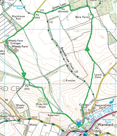
Walk 2 – Bere Farm and Wheely Farm (4¼ miles; no stiles; easy walking)
This walk stays entirely within the Parish and includes some of its most secluded and beautiful parts.
Walk north along Lippen Lane. Bear left after Hanover Cottages and at the end of the road keep straight on along the marked path across Bottom Field.
Cross straight over Bosenhill Lane. Here was once the Warnford Barn and a cottage or two. Continue on across the arable land, the path rising gently. At the tarmac lane turn left.
On the skyline to the left are the wooded strips along Bosenhill Lane. Up the slope to the right is Grove Copse. As you climb, the view across the valley behind opens up, with Old Winchester Hill and the northward ridge towards West Meon in clear sight. Before Bere Farm on the left is “Doodlebug Field” where a V1 flying bomb landed in 1944.
The drive arrives at the gate of Bere Farm, one of the quietest and most peaceful places in the Parish. Follow the track to the east of the farm buildings until it bends sharp right onto an old track which used to be the farm access road. Follow the track for about 100 yd to a track junction.
Turn left into Green Lane. Brockwood Copse (bluebells in early May) is on your right, with the old fields of Bere Farm (now part of the Warnford Estate) on your left. At the sharp right hand bend is the site of Bere Farm Cottages. Bere Barn was a hundred yards away across the field.
Keep on along Green Lane for about ¼ mile. The gently sloping hill on your right is Hurst Down, an old name not shown on the OS map but still reflected in the field names. Look for a track coming out on the left. This is the top of Bosenhill Lane. You can use this for a shorter return to Warnford if you don’t mind ruts and mud.
To follow our route, keep on along Green Lane for another 200 yards until it comes out in Riversdown Road. Turn left and follow the road for nearly ½ mile. At Wheely Farm turn left onto the concrete farm road and follow this up through the farm buildings. When this runs out keep straight on. The footpath follows an overgrown green lane between fields, lined by old trees.
Towards the top is a lovely area for spring flowers – primroses, wood anemones, violets and bluebells. Enter the wood and look for a footpath turning left off the track – it can be overgrown and hard to find at times.
When you come into the open, turn right and follow the field edge round the corner of “Little Hayes” and along until you get to the “Lone Oak” at the end of the hedge line. (You can take the official footpath line which runs diagonally across the field on the other side of the hedge, but it involves two stiles and a field of cattle). 50 yards straight in front of you is a seat, next to (one day it will be under) one of the Parish’s Jubilee Oaks, planted in 2012 (the other is in the playground). Here is one of the best views in Warnford, with the valley laid out in front of you.
When you have taken it in, go back to the Lone Oak and turn left, following the track down past Pinks Hill Copse. The view opens southwards towards Beacon Hill. Keep on down until you get to the village hall.
...............................................................................................................

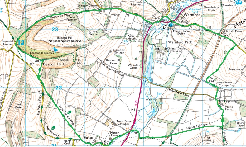
Walk 3 – Beacon Hill, Exton and Peake Farm (6½ miles, 4 stiles, steep hill to descend and a few rough sections, otherwise easy walking)
From the village hall walk south along Lippen Lane, follow the footpath beside the A32 for 150 yards then turn right up Wheely Down Road. Take care – it has some blind bends and traffic can move very fast.
After ½ mile, at Wheely Down Farm (look for the steel sculptures in the paddock in front), take the bridleway left. Climb the hill and after 200 yd turn right through a gate into the field, following the bridleway along the hedge line, climbing gently all the way. Follow the signs through a gate, passing a new coppice on the left. As you go the view opens up across the side valley southward. This is Abbey Estate land, with Beacon Hill (English Nature) beyond. Keep straight on along the track, which forms a headland between fields. Follow the bridleway through a gate and up through the wood – on the right is private woodland behind a deer fence. On the left is open access land managed by English Nature.
At the Beacon Hill car park take the track into the nature reserve, then at the top of the hill stop to admire the view – southward past Portsdown Hill to the Solent and the Isle of Wight, then westward past the Fawley chimneys to the New Forest and northward to Beacon Hill, Highclere.
From the viewpoint follow the signs for the South Downs Way (permissive bridleway) to the right, down the hill to the lane. Turn left, then immediately left again onto a footpath. Follow it on its steep descent of the slope, stopping on the way to admire the fantastic view across the Meon Valley. It doesn’t get much better than this! Descend through three kissing gates until the path levels out across fields towards Exton. Keep straight on until there is a choice of signed paths – bear left and follow on until you come out in Church Lane, Exton. Turn left.
At the T-junction - if you have time turn right and call in at “The Shoe”. If not, turn left, walking along the lane past Manor Farm House with the river on your right until you reach the A32. Cross straight over, down the track with the old-style “no through road” sign until you come to the footbridge over the river. Beyond here the path can be very muddy and wet in winter.
Where the path forks keep left and follow it beside a stream bed. This is Garden Hill Lane – the watercourse is completely dry in summer but a clear running chalk stream in winter. Follow the path (lumpy and needing care in places) until you reach a big brick arch bridge where the stream runs under the old railway line (now the Meon Valley Trail).
Climb the steps on the left and then decide whether to turn left and take the short route home via the Trail, or to go via Peake Farm. For the Peake Farm route cross straight over the Trail and at the bottom of the ramp bear left along the path next to the stream bed. Keep going until the path and the stream bed merge (you can be paddling here in winter). Over the gate on your right is the site of Garden Hill Farm – nothing left to see other than the beautiful location.
At the T-junction turn left and follow the concrete road towards Lower Peak Farm. This part of the walk is very quiet – the whole Peake Farm area feels much more remote than it actually is. Before entering the farm take the well-marked footpath on the left, skirting the farm buildings, across the lane and past the riding school. At the rough drive to Upper Peak Farm turn left and follow for ½ mile to Hayden Lane. Turn left and it’s another ½ mile back to Warnford.
...............................................................................................................